
GEOLOGY, LANDFORMS AND LAND USE
By Robin Stevenson and Ljuba GilesA more detailed PDF of the subject is available Here

In the following account some technical terms have been used. They have been italicised and are defined more fully in the Glossary at the end of the attached PDF, which gives a more detailed account of the geology for those wanting it.
The landforms of an area, the coastline, the high ground and the river valleys, all depend ultimately on the underlying geology. So too do the soil types, and the type of plants which grow naturally, or can be made to grow by farmers. Human use of the Gaywood Valley through the ages has been subject to this geological control.
Geology, like many other natural phenomena, does not recognise man-made divisions, so any account of the geology and landscapes of the Gaywood Valley needs to include rocks and landscapes extending somewhat beyond the confines of the Valley itself (Fig 1).
Geologists traditionally divide any account of rocks into two. The Solid Geology deals with the older, usually hardened or lithified, rocks. On top of these may lie younger Superficial Deposits which usually consist of loose uncemented sediments. They overlie and mask the underlying solid rocks and the processes responsible for their formation have helped to erode and sculpt the bedrock, to give us the present day landscape.
The geology of the area consists solely of sedimentary rocks, i.e. rocks made up of the detritus of other, older, rocks weathered, eroded, transported, and finally redeposited. Familiar examples include sands and sandstones, gravels and muds. Igneous and metamorphic rocks only occur very occasionally as fragments transported into the area by glaciers, though they have also been brought in by human activity, as ships ballast or as building and monumental materials.
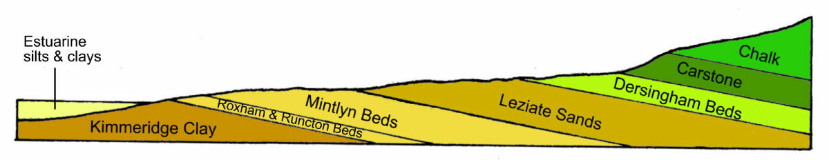
The 'solid' rocks have been gently tilted towards the east, with the oldest rocks occurring in the west, in Marshland, and the youngest in the east. The Jurassic Kimmeridge Clays in the west (150-155 million years old) are overlain by Cretaceous rocks, of which the youngest is the Chalk, which formed about 100-140 million years ago.
In terms of their importance in the landscape it is the hardest and the thickest beds which are most important. The hardest beds are more resistant to erosion and therefore usually form steeper slopes (and higher ground) whilst the thickest beds are going to occupy most country. The Mintlyn, Runcton and Roxham Beds are collectively not very thick and have little obvious effect on the landscape; along with the overlying Leziate Sands they form part of a rock unit called the Sandringham Sands.
The Superficial deposits all belong to the Pleistocene Period of geological time, which extends back to about 2.8 million years before the present. During the Quaternary there were a series of major climatic changes with episodes of very cold climate (Ice Ages or Glaciations), alternating with warmer (Interglacial) episodes. The detailed geology of the Quaternary is very complex and the experts are not fully agreed on the details of what occurred.
On a geological map the superficial deposits lie on top of the solid geology, usually as a complex patchwork, often with one set of superficial deposits lying on top of, and partially (or sometimes wholly) concealing others. The reason for this is that erosion by ice (and other agencies) often destroyed or buried sediments laid down during earlier phases of erosion and deposition.
As a result we are not entirely sure of events in the Gaywood Valley itself but can guess what was happening from evidence present in the Babingley valley to the north, and Nar valley to the south. We can be sure, however, that the present form of the Gaywood Valley has been caused by the interplay between glacial and periglacial activities, as well as the action of rivers, wind, and gravity.
LANDFORMS AND LANDSCAPES
The landscape of the area is subdued. The maximum heights, of around 90 metres, occur around Great Massingham and slopes are - at most - only moderate.
This subdued landscape is the result of the generally soft nature of the solid geology which would have responded easily to the powerful effects of glacial and periglacial forms of erosion (and deposition). These would have been further modified by subsequent marine and fluvial erosion and deposition.

The Jurassic Clayland
The soft Jurassic clays of the Fenland Basin were clearly powerfully eroded by Anglian ice; there may have been subsequent incursions of ice into the Fenland Basin, but by late Quaternary times the Basin was beginning to fill with soft sediments brought in by rivers draining northwards, towards the sea, and by estuarine salt marsh sediments being driven onshore by the sea itself. These deposits have largely covered and concealed the underlying Kimmeridge Clay, and they give us the flat Marshland of West Lynn and beyond, as well as the South and North Wootton marshes.
Originally all of this area would have been a mixture of swampy, marshy ground associated with the Ouse, and salt marsh. This would have provided abundant sources of food to early man, but almost all has been reclaimed for agriculture over the centuries.
The Fen Edge and the Lower Cretaceous Sands.
The Fen edge occurs where slightly higher ground, associated with the lower parts of the Sandringham Sands occurs. Positions along the Fen Edge would have been very attractive to early settlement as they allowed easy access to the resources of the salt marshes whilst also offering dry ground for building settlements, and soft easily worked soil for primitive ploughs, even though the soils were of poor quality.
Inland Landforms and Landscapes

The most important unit of the Sandringham Sands formation is the Leziate Sand, which forms most of the higher ground between the main rivers. It is a poorly cemented (and therefore soft) sand which, in general gives gentle rounded slopes. Where it has been quarried, however, it may retain steep slopes which add a certain drama to the landscape - as in the Bawsey Country Park. The infertile soils which form on it tend to swing in and out of agriculture, depending on economic circumstances.
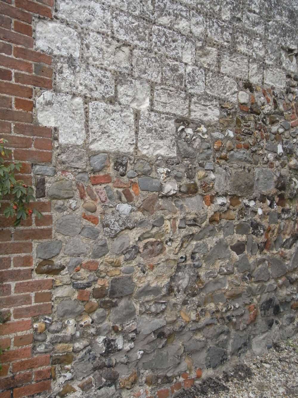
Around Castle Rising a well cemented form of Leziate Sand, the Silver Carr, occurred and this was worked as a building stone. It forms the bulk of the castle at Castle Rising, and is also incorporated into many local churches. Occasional slabs of it are still ploughed out of local fields.
The Dersingham Beds are, in the main also soft sands, but they too contain better cemented layers which can be worked to produce thin slabs of a foxy-brown sandstone which, as Small Carr, is used in local buildings. The overlying Carstone is also a source of building stone ('Big Carr') which is generally coarser, better cemented, and used in larger units. The Carstone forms the steep slope on the east side of the A149 as one drives towards Dersingham.
The Chalk is generally covered by younger superficial deposits and is only seen in Parish Pits, situated near the edge of the Chalk outcrop. Whilst some forms of Chalk can be used for building, its main use was as an agricultural fertiliser, in the form of Lime.
Effects of Erosion
Glacial erosion and deposition

The landforms that we see at present are very different from those existing at the height of the ice age; valleys, for instance, would have been much deeper, but they have been much modified by post glacial processes of erosion and deposition.
Glacial deposits come in two main types: those associated with the ice itself, and those associated with glacial melt water. Ice, because of the way it moves, is unable to separate (or sort) rock fragments of different size, so glacial deposits (known variously as boulder clay or till) are often made up of larger rock fragments set in a matrix of finer grained clay-like material. Water however, is usually able to sort rock particles of different sizes apart, separating coarse gravels from finer sands.
Within our area there are several patches of 'Chalky Boulder Clay'. It is called 'Chalky' Boulder Clay because it usually contains abundant clasts (pebbles) of Chalk eroded from the floor of the North Sea as the ice moved southwards. Because it is soft, and reasonably fertile it is favoured for cultivation.
By contrast the sands and gravels laid down by meltwater tend to form infertile soils. With a few exceptions they too do not form any dramatic landforms. Good examples occur near Congham, where the conifer plantations of Grimston Carr and Congham Heath grow on hummocky sands and gravels deposited by meltwater.
The glacial deposits overlying the Chalk in the upper Gaywood Valley are also infertile. In order to get at the underlying chalk (or marl) farmers dug pits, usually in the centre of each field. This was then spread over the fields to improve their fertility. Lime is now obtained from elsewhere but the pits - which have often been invaded by scrub - remain as a testimony to the underlying geology, and past agricultural practise.
River Erosion and Deposition.

During the Anglian glaciation erosion by ice would probably have deepened pre-existing river valleys which would have been further modified, at the end of the ice age, by raging melt-water rivers, capable of cutting wide deep valleys. The modern Babingley, Gaywood, Middleton Stop Drain and Nar are tiny in comparison to the size of their valleys.
As the volumes of melt-water decreased, deposition of sands and gravels would have occurred, helping to infill these glacial valleys, and the modern rivers have laid down silts and clays. Sands,and gravels have been exploited for building materials, and clays for brick making. Poorly drained river floodplains would probably been used originally as grazing land but most have subsequently been reclaimed for agriculture, by dint of straightening the rivers and by the digging of complex networks of dykes and ditches.
One of the notable features of the Gaywood and Babingley river is that their upper portions are dry - a valley exists, but no water flows down it. This is because the underlying rock is Chalk, which is a very porous type of limestone. Towards the end of glacial times, when the ground was frozen, then water would have been forced to flow over the surface, thus eroding a valley. Once the ice melted, however, the water would have been free to disappear underground.
Periglacial Erosion and Deposition

Both before and after an actual glaciation climatic conditions may be very cold in and around the advancing (or retreating) ice margins. Such conditions are referred to as periglacial.
A variety of processes may occur in frozen ground, including processes which sort the material, arranging it into patterns of circles or stripes. These patterns may survive in the soil and influence crop growth - plants grow better in finer grained, more moisture retentive soils, and less well in coarser, more freely draining material. This can be seen on the ground but is usually much more easily seen on aerial photographs.